Follow us
  • Facebook
  • Instagram
  • Linkedin
  • Twitter
  • YouTube
en
  • Italian
  • English
Log in
OGS  Home
Search

Search

Main Menu

  • The institute
    • About Us

      • Vision, mission and values
      • History
      • Governance
      • Organisation
      • Documents
    • Section of Oceanography

      • Physical Oceanography Group
      • Chemical and Biological Oceanography
      • Dynamics of Ecosystems and Computational Oceanography
      • Oceanographic Research Infrastructures and Laboratories
    • Section of 
Geophysics

      • Geology and Marine Geophysics
      • Applied and Exploration Geophysics
      • Geophysics Research Infrastructures and Laboratories
    • Center for Seismological Research

      • Seismology and Geodesy
      • Engineering Sesimology
      • Seismological Research Infrastructures and Laboratories
    • Centre for Management of Maritime Infrastructures

      • Ship Management Group
      • Naval infrastructures
  • Activities
    • Missions

      • Sea and Ocean
      • Earth processes
      • Natural risk
      • Polar areas
      • Open science
    • Research

      • Projects
      • Progetti PNRR
      • Bulletin of Geophysics and Oceanography
      • National Group of Solid Earth Geophysics (GNGTS)
      • Networks, associations and consortia
      • Publications
    • Innovation

      • Applied research and services
      • Patents and inventions
      • Technology clusters
      • Industrial partners
    • Science for Society

      • External relations
      • Advanced training
      • Trieste Laboratory on Quantitative Sustainability (TLQS)
      • Communication and dissemination
      • Citizen science
      • Scientific and environmental diplomacy
  • Infrastructures
    • Maritime infrastructures

      • Research vessel Laura Bassi
      • Other boats
    • European Infrastructures

      • European contribution to the Argo programme (Euro-Argo ERIC)
      • European Carbon Dioxide Capture and Storage Laboratory Infrastructure (ECCSEL ERIC)
      • Partnership for Advanced Computing in Europe (PRACE)
      • Other European Infrastructures
    • Oceanographic Infrastructures

      • Gulf of Trieste Platform
      • Capo Granitola Observatory
      • Glider Station
      • National Oceanographic Data Centre (NODC)
      • Oceanographic Calibration and Metrology Center (CTMO)
      • Technological development and support for acquisitions in the field (TEC)
      • Collection of Marine Microorganisms (CoSMi)
      • Testing tank
      • Marine Chemistry and Biology Laboratories (BioMarine Lab)
      • Arctic marine observing system
      • High Performance Computing Laboratory (HPC-TRES)
    • Geophysical Infrastructures

      • Geophysical exploration infrastructure (GeoExp)
      • Aerial remote sensing facility (AiRS)
      • Well geophysics facility (PITOP)
      • Geophysical data distribution facilities
      • Processing data center
      • Terrestrial Geology Lab
      • Laboratory of Marine Geology
      • Seismic software Lab (SEISLAB)
      • Laboratorio multi-sensor core logger
    • Seismological and Geodetic Infrastructures

      • Northeast Italy monitoring system (SMINO)
      • Antarctic Seismographic Argentinean Italian Network (ASAIN)
      • Everest Seismological Station (EvK2-CNR)
      • Facilities for distribution of seismic & geodetic data
      • Seismological Calibration Centre
      • Field seismic networks and Mobile Labs
      • Seismic monitoring of industrial activities
      • Geodetic Monitoring of Landslide Phenomena
      • Sensor Development Laboratory
  • People
    • Contacts
    • Human Resource Strategy for Researchers (HRS4R)
    • Support for foreign researchers
    • Mobility
  • Work with us
    • Gare e appalti
    • Concorsi
    • Altre opportunità
    • Professional qualification
  • News
    • News
    • Press release
    • Cinque per mille
    • Press Office
    • Press resources
  • Contacts
    • Offices
    • Public Relations Office
    • Institutional contacts
    • Data protection officer

Dynamics of Ecosystems and Computational Oceanography

Numerical analysis, synthesis, integration and modelling of the state and dynamics of marine ecosystems.

Modelli oceanografici nel Mar Mediterraneo
  1. Home/
  2. Section of Oceanography/
  3. Dynamics of Ecosystems and Computational Oceanography

Understanding and quantitatively representing the dynamics of marine, coastal and lagoon ecosystems, through the development and use of numerical analysis methods and models of different complexity that describe and integrate physical, biogeochemical and ecological dynamics at different spatial and temporal scales, also using artificial intelligence and supercomputing technologies.

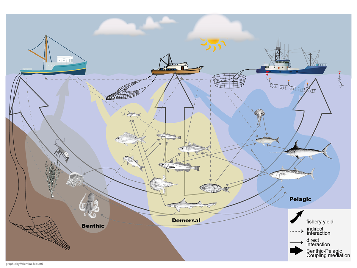
The group addresses scientific questions related to interactions between physics and biogeochemistry, anthropogenic impact on marine systems at different spatial-temporal scales, study of ecosystems functioning and their biodiversity, simulation of trophic networks and ecosystem approach to fisheries and aquaculture, operational oceanography, integrated analysis of ecological-socio-economic systems, sustainable development, integrated coastal zone management. 

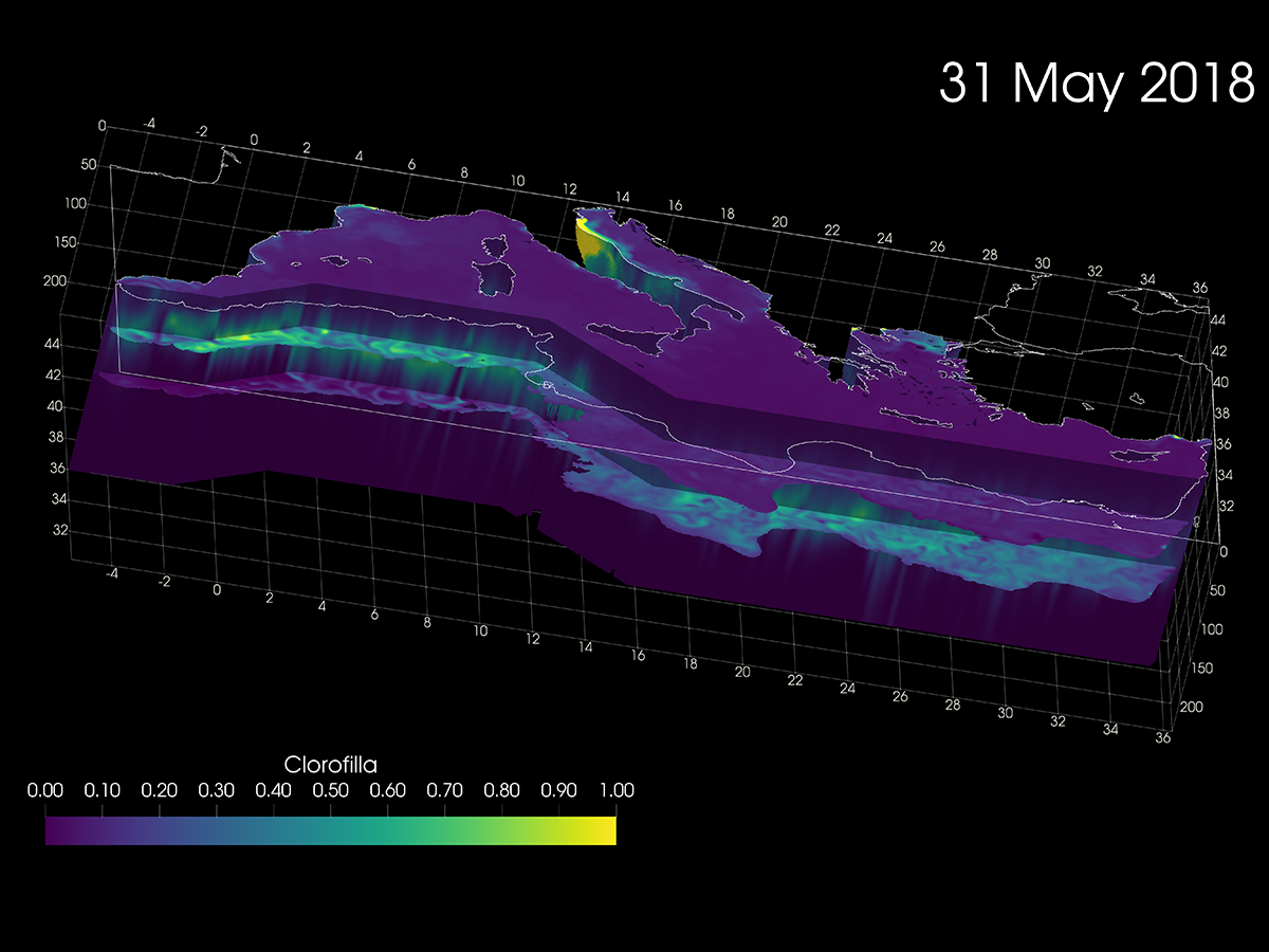
The areas of interest include the Mediterranean Sea, the Adriatic-Ionian system, the Northern Adriatic Sea and its lagoon systems, the Strait of Sicily.

The research topics are included in the outcomes of the Ocean Decade:

A clean ocean where sources of pollution are identified and removed

  • Studies on the vulnerability of marine, coastal and lagoon ecosystems in relation to environmental risks, such as oil spills, microplastics and other pollutants in the sea, and impacts related to the mercury cycle, including methylmercury.
  • Traditional and next-generation statistical methods to assess the quality of waters and marine systems, to support environmental agencies and implement national and international directives.

A healthy and resilient ocean where marine ecosystems are mapped and protected

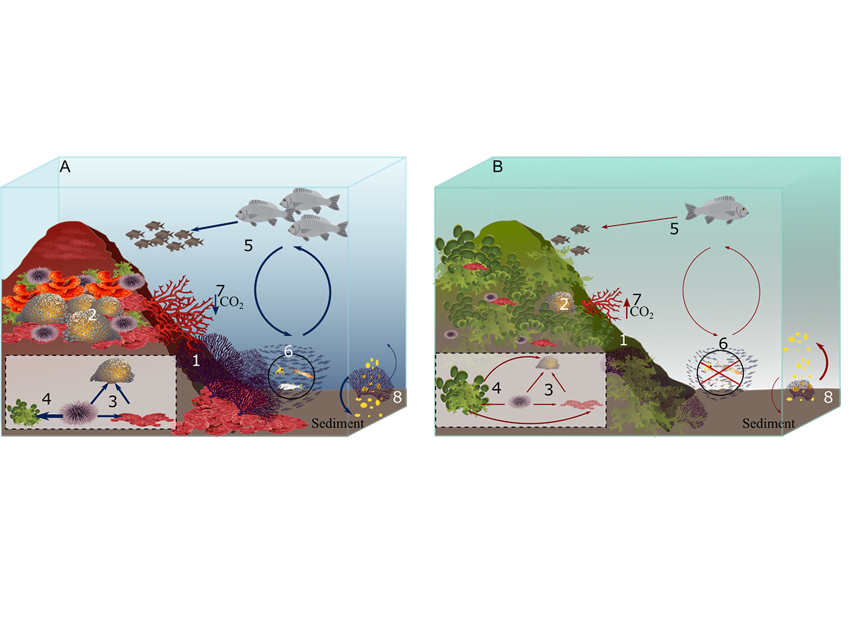
  • Analysis of trophic networks and spatial distribution of marine organisms in relation to environmental variables to identify ecological niches, explore population dynamics, ecosystem health and biodiversity, and to explain and predict possible variations at different spatio-temporal scales.
  • Study of carbon and nutrient cycles, and of the interactions between biological, physical, optical and chemical components as a basis for understanding the functioning, dynamics and changes in marine ecosystems.

A predictable ocean in which society has the ability to understand current and future ocean conditions

  • Reconstructions of past and simulations of future scenarios to assess the impacts of increased atmospheric CO2 and other anthropogenic activities (changes in land use, nutrient and pollutant loads in coastal areas, fishing pressures) on biogeochemistry, distribution of organisms of different trophic levels and habitats.
  • Development and implementation of data assimilation techniques, a key aspect of predictive capacity to obtain an optimal estimate of the true state of the ocean.

A safe ocean where people are protected from hazards and extreme events

  • Operational ocean forecasting systems integrating remote observations, in situ measurements and numerical models, for monitoring the state of the oceans, the blue economy and the protection and management of marine ecosystems.
  • Study of ecological dynamics resulting from the introduction of alien species, and of toxic algal blooms.

A sustainably exploited ocean that ensures food supply

  • Ecosystem approach to fisheries and aquaculture through the analysis of trophic data, marine networks and trophic chains, and the use of integrated modelling approaches to provide a scientific basis to support decision-makers in evaluating possible management alternatives, considering ecological, social and economic aspects. 
  • Analysis of ecosystem services to support integrated and sustainable management of marine and coastal areas through quantitative methods of ecological and socio-economic analysis to analyse ecological functions and processes, capacities, flows, and demand for goods and services from the ecosystem to humans.

A transparent ocean with open access to data, information and technologies

  • Within the EU Copernicus Marine Services, we are responsible for producing forecasts and reanalyses of the biogeochemistry of the Mediterranean Sea and, as a downstream service, we operate an operational system for forecasting the physical and biogeochemical state of the northern Adriatic Sea. The data and software used are aligned with the FAIR philosophy.
  • We manage the participation of OGS in the PRACE-Italy infrastructure in which other sections of OGS also collaborate. With the support of CINECA, we have implemented the training programme "HPC Training and Research for Earth Sciences" (HPC-TRES) for the use of HPC technologies in Earth Sciences.
  • The tools are based on a quantitative approach that exploits the potential of High Performance Computing (HPC) to increase spatial resolution and enhance the complexity of the physical, biogeochemical and ecological processes described in the numerical algorithms.

An inspiring and engaging ocean

  • The group contributes to educational and dissemination activities at different levels, from participation in public events, to teaching in university courses, masters and doctorates, to the organisation of international congresses and schools (e.g. ECEM, AMAREMED, EuroGOOS Ocean Literacy Network).
Campo 3D di clorofilla nel Mar Mediterraneo realizzato con le tecnologie di calcolo ad alte prestazioni dell’infrastruttura PRACE.
Coralligeno
Pesca e rete trofica

Footer menu

Institute

  • About Us
  • Organisation
  • Section of Oceanography
  • Section of 
Geophysics
  • Center for Seismological Research
  • Centre for Management of Maritime Infrastructures

Activity

  • Missions
  • Research
  • Innovation
  • Science for Society
  • Real time data

Infrastructures

  • Maritime infrastructures
  • European Infrastructures
  • Oceanographic Infrastructures
  • Geophysical Infrastructures
  • Seismological and Geodetic Infrastructures

Other

  • People
  • Job opportunity
  • Tenders (IT)
  • Human Resource Strategy (HRS4R)
  • News
  • Intranet
OGS  Home

Contacts

National Institute of Oceanography and Applied Geophysics - OGS
Borgo Grotta Gigante 42/C
34010 - Sgonico ( TS ) - Italy
Tel.+39 040 21401
Fax.+39 040 327307

C.F./P.IVA : 00055590327
Posta Elettronica Certificata: ogs@pec.it

Institute links

  • Albo pretorio
  • Amministrazione trasparente
  • Accesso civico
  • Dichiarazione di accessibilità
Follow us
  • Facebook
  • Instagram
  • Linkedin
  • Twitter
  • YouTube

Small prints

Useful links section

  • Privacy and cookie policy
  • Legal
  • Social media policy