Follow us
  • Facebook
  • Instagram
  • Linkedin
  • Twitter
  • YouTube
en
  • Italian
  • English
Log in
OGS  Home
Search

Search

Main Menu

  • The institute
    • About Us

      • Vision, mission and values
      • History
      • Governance
      • Organisation
      • Documents
      • Onorificenze
    • Section of Oceanography

      • Physical Oceanography Group
      • Chemical and Biological Oceanography
      • Dynamics of Ecosystems and Computational Oceanography
      • Oceanographic Research Infrastructures and Laboratories
    • Section of 
Geophysics

      • Geology and Marine Geophysics
      • Applied and Exploration Geophysics
      • Geophysics Research Infrastructures and Laboratories
    • Center for Seismological Research

      • Seismology and Geodesy
      • Engineering Sesimology
      • Seismological Research Infrastructures and Laboratories
    • Centre for Management of Maritime Infrastructures

      • Ship Management Group
      • Naval infrastructures
  • Activities
    • Missions

      • Seas and Ocean
      • Earth processes
      • Natural risk
      • Polar areas
      • Open science
    • Research

      • Projects
      • Attuazione misure PNRR
      • Bulletin of Geophysics and Oceanography
      • National Group of Solid Earth Geophysics (GNGTS)
      • Networks, associations and consortia
      • Publications
    • Innovation

      • Applied research and services
      • Patents and inventions
      • Technology clusters
      • Industrial partners
    • Science for Society

      • External relations
      • Blue Skills
      • High Performance Computing Laboratory (HPC-TRES)
      • The Laboratory on Quantitative Sustainability (TLQS)
      • Communication and dissemination
      • Citizen science
      • Game based learning
      • Scientific and environmental diplomacy
  • Infrastructures
    • Maritime infrastructures

      • Research vessel Laura Bassi
      • European contribution to the Argo programme (Euro-Argo ERIC)
      • Glider Station
      • Geophysical exploration infrastructure (GeoExp)
      • Aerial remote sensing facility (AiRS)
      • Field seismic networks and Mobile Labs
      • Sistemi autonomi sottomarini
      • Other boats
    • Oceanographic Infrastructures

      • Northeast Italy monitoring system (SMINO)
      • Gulf of Trieste Platform
      • European Multidisciplinary Seafloor and water-column Observatory (EMSO ERIC)
      • Capo Granitola Observatory
      • Arctic marine observing system
      • Antarctic Seismographic Argentinean Italian Network (ASAIN)
      • Everest Seismological Station (EvK2-CNR)
      • Geodetic Monitoring of Landslide Phenomena
      • Seismic monitoring of industrial activities
    • Laboratori sperimentali e centri di taratura

      • European Carbon Dioxide Capture and Storage Laboratory Infrastructure (ECCSEL ERIC)
      • Marine Chemistry and Biology Laboratories (BioMarine Lab)
      • Oceanographic Calibration and Metrology Center (CTMO)
      • Technological development and support for acquisitions in the field (TEC)
      • Collection of Marine Microorganisms (CoSMi)
      • Borehole geophysical test site (PiTOP)
      • Laboratorio multi-sensor core logger
      • Seismological Calibration Centre
      • Sensor Development Laboratory
    • Geophysical Infrastructures

      • Partnership for Advanced Computing in Europe (PRACE)
      • National Oceanographic Data Centre (NODC)
      • Geophysical data distribution facilities
      • Processing data center
      • Facilities for distribution of seismic & geodetic data
      • Seismic software Lab (SEISLAB)
  • People
    • Contacts
    • HR Excellence in Research
    • Support for foreign researchers
    • Mobility
    • Associated personnel
  • Work with us
    • Gare e appalti
    • Concorsi
    • Altre opportunità
    • Professional qualification
    • Occupational health and safety
    • Qualità
  • News
    • News
    • Press release
    • Cinque per mille
    • Press Office
    • Press resources
  • Contacts
    • Offices
    • Institutional contacts
    • Public Relations Office
    • Data protection officer
    • Responsabile per la Transizione al Digitale

Aerial remote sensing facility (AiRS)

Telerilevamento Trieste
  1. Home/
  2. Maritime infrastructures/
  3. Aerial remote sensing facility (AiRS)

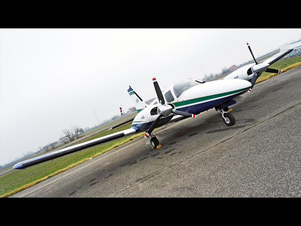
The Aerial remote sensing facility (AiRS) infrastructure groups all the technological and scientific skills required for the management of our aerial and terrestrial remote sensing / acquisition activities carried out using our airplane (a Piper PA-34-220 T Seneca III) and our drones. The group designs and plans the acquisition, processing and interpretation of remote sensing, cartographic, gravimetric and environmental data. In addition, it develops and manages active and passive airborne and terrestrial remote sensing systems for technological, engineering, geophysical and environmental applications.

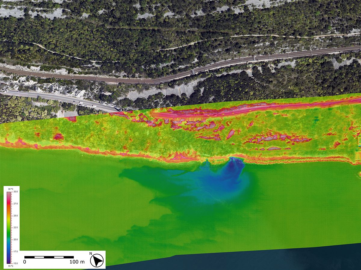
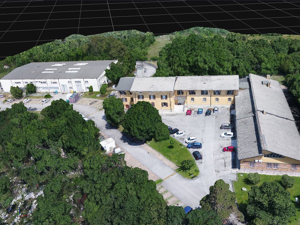
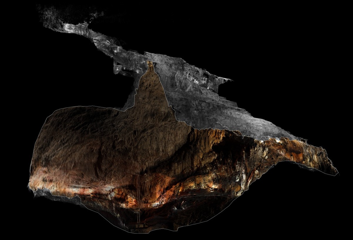
The group has all the skills required for the acquisition of photogrammetric, orthophoto, LIDAR, hyperspectral, thermographic, environmental and gravimetric data acquired not only from aerial but also from terrestrial and marine platforms.

Organisation

OGS Contact
Paolo Paganini
Documents
Equipment inventory
Santa Croce filtri TS -anomalie termiche dovute a risorgenze carsiche - mosaico termografico sovrapposto all_ortofotopiano_Paganini_Pavan
Velivolo_Piper_Seneca_III_I-LACA_3_Paganini_Pavan
mesh con texture ricavata da rilievo drone_ogs_pavan-paganini
Rilievo laser scanner terrestre del comprensorio della Grotta Gigante (sezione longitudinale)_Pavan_Paganini

Organisation

OGS Contact
Paolo Paganini
Documents
Equipment inventory

Footer menu

Institute

  • About Us
  • Organisation
  • Section of Oceanography
  • Section of 
Geophysics
  • Center for Seismological Research
  • Centre for Management of Maritime Infrastructures

Activity

  • Missions
  • Research
  • Innovation
  • Science for Society
  • Real time data

Infrastructures

  • Maritime infrastructures
  • European Infrastructures
  • Oceanographic Infrastructures
  • Geophysical Infrastructures
  • Seismological and Geodetic Infrastructures

Other

  • People
  • Job opportunity
  • Tenders (IT)
  • Human Resource Strategy (HRS4R)
  • News
  • Intranet
OGS  Home

Contacts

National Institute of Oceanography and Applied Geophysics - OGS
Borgo Grotta Gigante 42/C
34010 - Sgonico ( TS ) - Italy
Tel.+39 040 21401
Fax.+39 040 327307

C.F./P.IVA : 00055590327
Posta Elettronica Certificata: ogs@pec.it

Institute links

  • Albo pretorio
  • Amministrazione trasparente
  • Accesso civico
  • Dichiarazione di accessibilità
  • Segnalazione di accessibilità
  • Statistiche web
Follow us
  • Facebook
  • Instagram
  • Linkedin
  • Twitter
  • YouTube

Small prints

Useful links section

  • Privacy and cookie policy
  • Legal
  • Social media policy