Follow us
  • Facebook
  • Instagram
  • Linkedin
  • Twitter
  • YouTube
en
  • Italian
  • English
Log in
OGS  Home
Search

Search

Main Menu

  • The institute
    • About Us

      • Vision, mission and values
      • History
      • Governance
      • Organisation
      • Documents
      • Onorificenze
    • Section of Oceanography

      • Physical Oceanography Group
      • Chemical and Biological Oceanography
      • Dynamics of Ecosystems and Computational Oceanography
      • Oceanographic Research Infrastructures and Laboratories
    • Section of 
Geophysics

      • Geology and Marine Geophysics
      • Applied and Exploration Geophysics
      • Geophysics Research Infrastructures and Laboratories
    • Center for Seismological Research

      • Seismology and Geodesy
      • Engineering Sesimology
      • Seismological Research Infrastructures and Laboratories
    • Centre for Management of Maritime Infrastructures

      • Ship Management Group
      • Naval infrastructures
  • Activities
    • Missions

      • Seas and Ocean
      • Earth processes
      • Natural risk
      • Polar areas
      • Open science
    • Research

      • Projects
      • Attuazione misure PNRR
      • Bulletin of Geophysics and Oceanography
      • National Group of Solid Earth Geophysics (GNGTS)
      • Networks, associations and consortia
      • Publications
    • Innovation

      • Applied research and services
      • Patents and inventions
      • Technology clusters
      • Industrial partners
    • Science for Society

      • External relations
      • Blue Skills
      • High Performance Computing Laboratory (HPC-TRES)
      • The Laboratory on Quantitative Sustainability (TLQS)
      • Communication and dissemination
      • Citizen science
      • Game based learning
      • Scientific and environmental diplomacy
  • Infrastructures
    • Maritime infrastructures

      • Research vessel Laura Bassi
      • Other boats
    • European Infrastructures

      • European contribution to the Argo programme (Euro-Argo ERIC)
      • European Carbon Dioxide Capture and Storage Laboratory Infrastructure (ECCSEL ERIC)
      • Partnership for Advanced Computing in Europe (PRACE)
      • Other European Infrastructures
    • Oceanographic Infrastructures

      • Gulf of Trieste Platform
      • Capo Granitola Observatory
      • Glider Station
      • National Oceanographic Data Centre (NODC)
      • Oceanographic Calibration and Metrology Center (CTMO)
      • Technological development and support for acquisitions in the field (TEC)
      • Collection of Marine Microorganisms (CoSMi)
      • Testing tank
      • Marine Chemistry and Biology Laboratories (BioMarine Lab)
      • Arctic marine observing system
    • Geophysical Infrastructures

      • Geophysical exploration infrastructure (GeoExp)
      • Aerial remote sensing facility (AiRS)
      • Borehole geophysical test site (PiTOP)
      • Geophysical data distribution facilities
      • Processing data center
      • Terrestrial Geology Lab
      • Laboratory of Marine Geology
      • Seismic software Lab (SEISLAB)
      • Laboratorio multi-sensor core logger
    • Seismological and Geodetic Infrastructures

      • Northeast Italy monitoring system (SMINO)
      • Antarctic Seismographic Argentinean Italian Network (ASAIN)
      • Everest Seismological Station (EvK2-CNR)
      • Facilities for distribution of seismic & geodetic data
      • Seismological Calibration Centre
      • Field seismic networks and Mobile Labs
      • Seismic monitoring of industrial activities
      • Geodetic Monitoring of Landslide Phenomena
      • Sensor Development Laboratory
  • People
    • Contacts
    • HR Excellence in Research
    • Support for foreign researchers
    • Mobility
    • Associated personnel
  • Work with us
    • Gare e appalti
    • Concorsi
    • Altre opportunità
    • Professional qualification
    • Occupational health and safety
  • News
    • News
    • Press release
    • Cinque per mille
    • Press Office
    • Press resources
  • Contacts
    • Offices
    • Institutional contacts
    • Public Relations Office
    • Data protection officer
    • Responsabile per la Transizione al Digitale

Northeast Italy monitoring system (SMINO)

smino
  1. Home/
  2. Seismological and Geodetic Infrastructures/
  3. Northeast Italy monitoring system (SMINO)

SMINO contributes to fulfilling the CRS institutional tasks, which, as provided by law 399/1989, has the task of surveillance and research on seismic activity in North-eastern Italy, also for Civil Protection purposes.
SMINO consists of a seismic network, a strong motion network and a geodetic monitoring network (FReDNet). SMINO is an infrastructure of national importance (PNIR 2021-2027).

SMINO operates in close cooperation with national and international networks in neighbouring countries, under framework agreements for real-time data exchange. Information on seismic events is disseminated to the public through a dedicated web portal dedicated web portal.

Seismic bulletins containing information on earthquakes recorded in North-eastern Italy are published regularly.


North-East Italy Seismometer Network

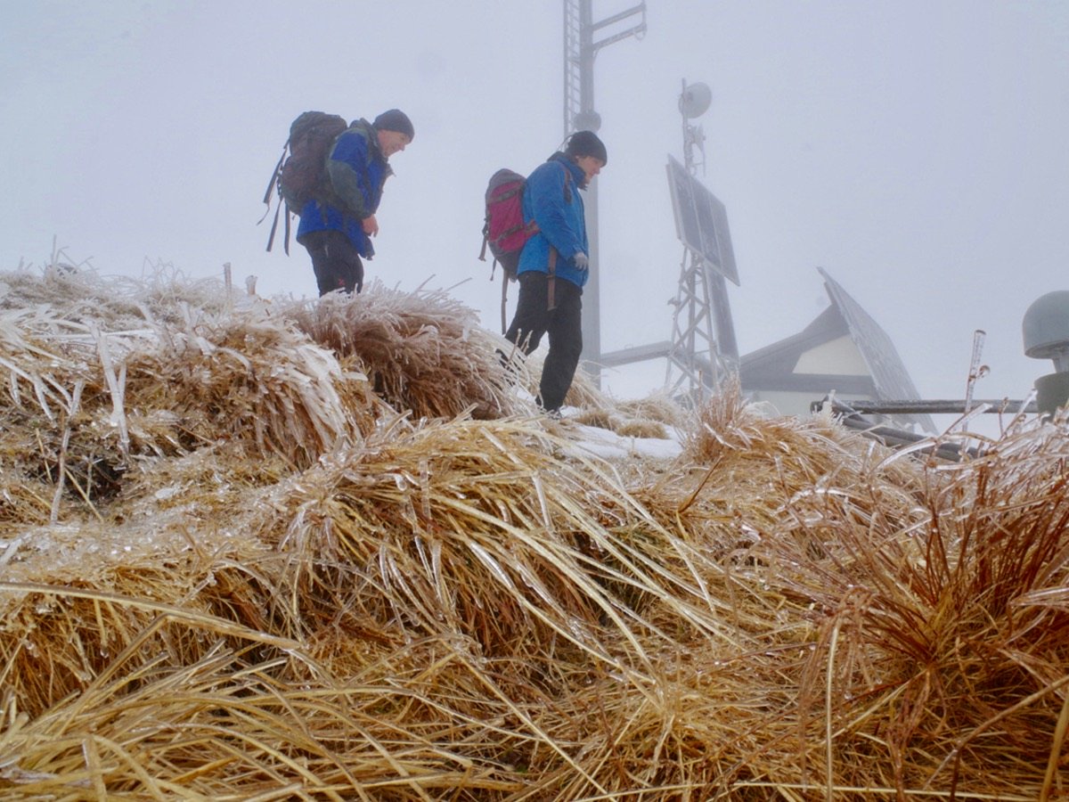
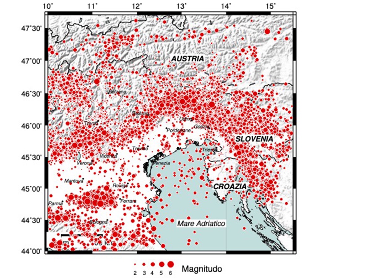
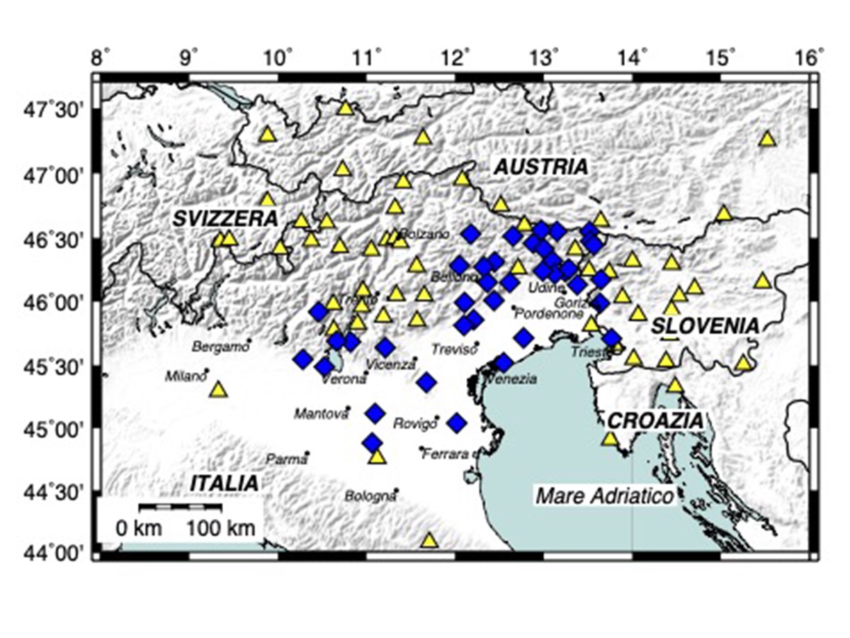
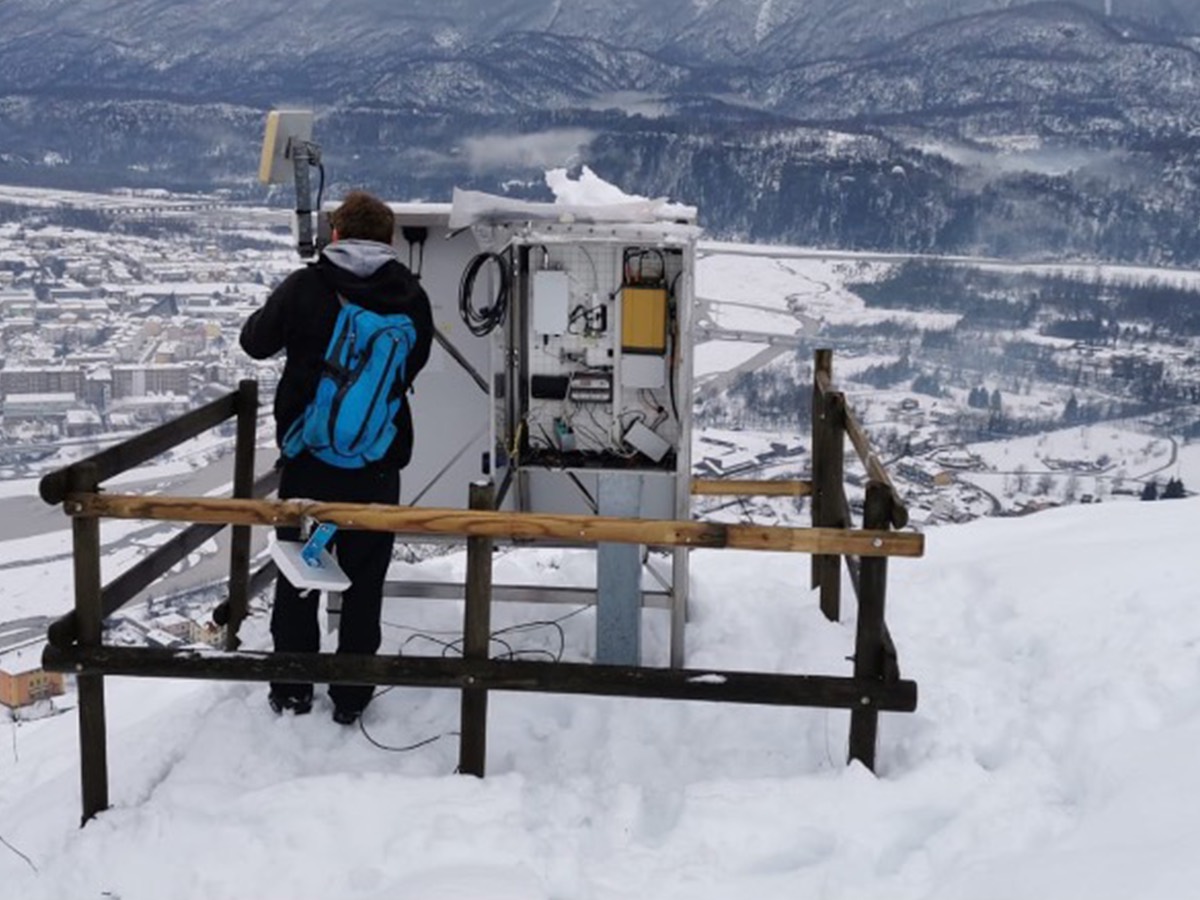
The North-eastern Italy Seismic Network consists of 43 stations, of which 24 broadband, 15 short-period and 4 intermediate-period. The Network is managed by OGS also on behalf of the Friuli Venezia Giulia and Veneto Regions. The stations are installed in Friuli Venezia Giulia, Veneto (in most cases), Emilia Romagna and Lombardy. The data recorded by all the stations are acquired in real time at the OGS Centre for Seismological Research in Udine.

The Network also provides data to the national seismic surveillance system, with real-time data exchange with the Civil Protection Department and the National Institute of Geophysics and Volcanology (INGV). Moreover, in order to improve the quality of localizations and magnitude estimation in border regions, the Network exchanges real-time data with the seismic networks of Austria, Slovenia, Switzerland, and the Autonomous Provinces of Trento and Bolzano, and the University of Genoa.

The North-eastern Italy Seismic Network is part of the CE3RN cross-border network in which also the seismic networks of Croatia, Slovakia, Hungary, Romania, Albania and Bulgaria participate.  CE3RN is an example of excellence in transnational collaboration and sharing of infrastructure, data and resources. Network data are made available through OASIS, EIDA and the RTS system.

Organisation

OGS Contact
Paolo Comelli
Info

Northeast Italy monitoring system (SMINO)
www.rts.crs.inogs.it

Seismic bulletins of Friuli Venezia Giulia Region
www.crs.inogs.it

Archive System of Instrumental Seismology (OASIS)
www.oasis.crs.inogs.it

Friuli Regional Deformation Network (FReDNet) 
www.frednet.crs.ogs.it

Rete sismometrica dell’Italia nord-orientale
FReDNet
FReDNet
Mappa sismicità 1977-2020
 Mappa stazioni

Strong motion Network 

In order to guarantee the correct recording also of strong seismic events, 29 stations of the seismic network were also equipped with high quality strong motion sensors. Moreover, within the "Sentinel Buildings" projects financed by the Regional Civil Protection of the Autonomous Region of Friuli Venezia Giulia and the Interreg V-A Italy-Austria project Armonia, and the Venet-one project, other medium cost strong motion sensors (more than 100) have been installed. The network data are acquired in real time and their processing contributes to the rapid estimation of the impact of seismic events.


Friuli Regional Deformation Network (FReDNet)

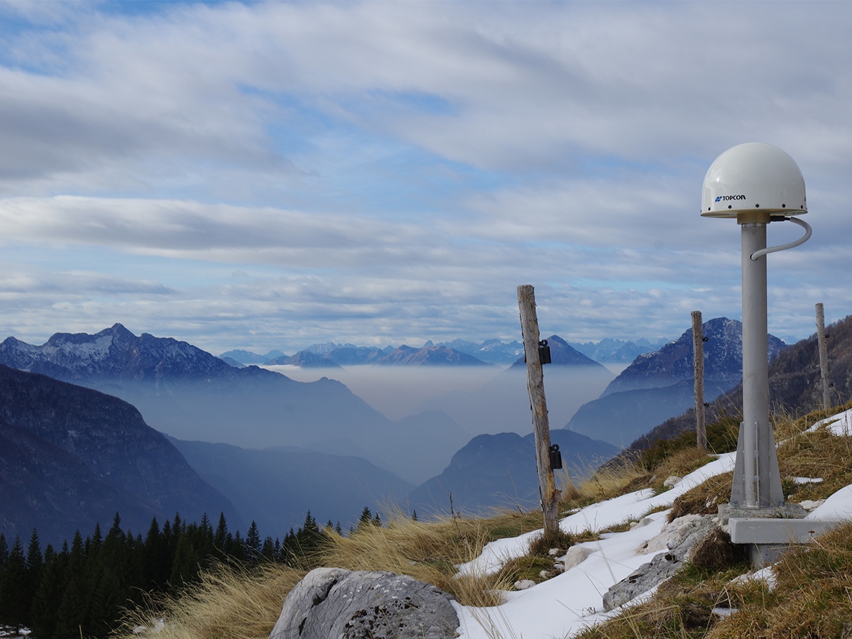
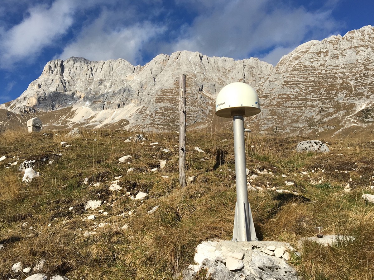
FReDNet (Friuli Regional Deformation Network) is the system for monitoring crustal deformations in Friuli Venezia Giulia that the Seismological Research Center began to develop in 2002, with the installation of the first station. In most cases, the receivers were installed in the sites already hosting the sensors of the OGS seismic network. FReDNet is also part of a larger program for geodetic survey of the Adriatic microplate that includes the repetition of episodic measurements of geodetic points. Currently FReDNet includes 22 permanent GNSS receivers (GPS+GLONASS+Galileo) for the geodetic monitoring of crustal deformations in north-eastern Italy. It also provides a service for high-precision georeferenced navigation in real time according to the differential correction modes (RTK - Real Time Kinematic, MRS - Multi Reference Station and VRS - Virtual Reference Station). The service is freely accessible to public, private and scientific users. The network is integrated with the GNSS network of the Friuli Venezia Giulia Region, with the National Dynamic Network of the Military Geographic Institute and with the European EUREF Permanent Network. The data of the FReDNet network are also distributed on the European EPOS node CEGNxEPOS managed by OGS.

Operazioni di manutenzione su una delle stazioni della rete di monitoraggio sismico e geodetico (SMINO)
Antenna GNSS della rete SMINO installata sui Piani di Montasio
FReDNet

Organisation

OGS Contact
Paolo Comelli
Info

Northeast Italy monitoring system (SMINO)
www.rts.crs.inogs.it

Seismic bulletins of Friuli Venezia Giulia Region
www.crs.inogs.it

Archive System of Instrumental Seismology (OASIS)
www.oasis.crs.inogs.it

Friuli Regional Deformation Network (FReDNet) 
www.frednet.crs.ogs.it

Footer menu

Institute

  • About Us
  • Organisation
  • Section of Oceanography
  • Section of 
Geophysics
  • Center for Seismological Research
  • Centre for Management of Maritime Infrastructures

Activity

  • Missions
  • Research
  • Innovation
  • Science for Society
  • Real time data

Infrastructures

  • Maritime infrastructures
  • European Infrastructures
  • Oceanographic Infrastructures
  • Geophysical Infrastructures
  • Seismological and Geodetic Infrastructures

Other

  • People
  • Job opportunity
  • Tenders (IT)
  • Human Resource Strategy (HRS4R)
  • News
  • Intranet
OGS  Home

Contacts

National Institute of Oceanography and Applied Geophysics - OGS
Borgo Grotta Gigante 42/C
34010 - Sgonico ( TS ) - Italy
Tel.+39 040 21401
Fax.+39 040 327307

C.F./P.IVA : 00055590327
Posta Elettronica Certificata: ogs@pec.it

Institute links

  • Albo pretorio
  • Amministrazione trasparente
  • Accesso civico
  • Dichiarazione di accessibilità
  • Statistiche web
Follow us
  • Facebook
  • Instagram
  • Linkedin
  • Twitter
  • YouTube

Small prints

Useful links section

  • Privacy and cookie policy
  • Legal
  • Social media policy