Follow us
  • Facebook
  • Instagram
  • Linkedin
  • Twitter
  • YouTube
en
  • Italian
  • English
Log in
OGS  Home
Search

Search

Main Menu

  • The institute
    • About Us

      • Vision, mission and values
      • History
      • Governance
      • Organisation
      • Documents
      • Onorificenze
    • Section of Oceanography

      • Physical Oceanography Group
      • Chemical and Biological Oceanography
      • Dynamics of Ecosystems and Computational Oceanography
      • Oceanographic Research Infrastructures and Laboratories
    • Section of 
Geophysics

      • Geology and Marine Geophysics
      • Applied and Exploration Geophysics
      • Geophysics Research Infrastructures and Laboratories
    • Center for Seismological Research

      • Seismology and Geodesy
      • Engineering Sesimology
      • Seismological Research Infrastructures and Laboratories
    • Centre for Management of Maritime Infrastructures

      • Ship Management Group
      • Naval infrastructures
  • Activities
    • Missions

      • Seas and Ocean
      • Earth processes
      • Natural risk
      • Polar areas
      • Open science
    • Research

      • Projects
      • Attuazione misure PNRR
      • Bulletin of Geophysics and Oceanography
      • National Group of Solid Earth Geophysics (GNGTS)
      • Networks, associations and consortia
      • Publications
    • Innovation

      • Applied research and services
      • Patents and inventions
      • Technology clusters
      • Industrial partners
    • Science for Society

      • External relations
      • Blue Skills
      • High Performance Computing Laboratory (HPC-TRES)
      • The Laboratory on Quantitative Sustainability (TLQS)
      • Communication and dissemination
      • Citizen science
      • Game based learning
      • Scientific and environmental diplomacy
  • Infrastructures
    • Maritime infrastructures

      • Research vessel Laura Bassi
      • Other boats
    • European Infrastructures

      • European contribution to the Argo programme (Euro-Argo ERIC)
      • European Carbon Dioxide Capture and Storage Laboratory Infrastructure (ECCSEL ERIC)
      • Partnership for Advanced Computing in Europe (PRACE)
      • Other European Infrastructures
    • Oceanographic Infrastructures

      • Gulf of Trieste Platform
      • Capo Granitola Observatory
      • Glider Station
      • National Oceanographic Data Centre (NODC)
      • Oceanographic Calibration and Metrology Center (CTMO)
      • Technological development and support for acquisitions in the field (TEC)
      • Collection of Marine Microorganisms (CoSMi)
      • Testing tank
      • Marine Chemistry and Biology Laboratories (BioMarine Lab)
      • Arctic marine observing system
    • Geophysical Infrastructures

      • Geophysical exploration infrastructure (GeoExp)
      • Aerial remote sensing facility (AiRS)
      • Borehole geophysical test site (PiTOP)
      • Geophysical data distribution facilities
      • Processing data center
      • Terrestrial Geology Lab
      • Laboratory of Marine Geology
      • Seismic software Lab (SEISLAB)
      • Laboratorio multi-sensor core logger
    • Seismological and Geodetic Infrastructures

      • Northeast Italy monitoring system (SMINO)
      • Antarctic Seismographic Argentinean Italian Network (ASAIN)
      • Everest Seismological Station (EvK2-CNR)
      • Facilities for distribution of seismic & geodetic data
      • Seismological Calibration Centre
      • Field seismic networks and Mobile Labs
      • Seismic monitoring of industrial activities
      • Geodetic Monitoring of Landslide Phenomena
      • Sensor Development Laboratory
  • People
    • Contacts
    • HR Excellence in Research
    • Support for foreign researchers
    • Mobility
    • Associated personnel
  • Work with us
    • Gare e appalti
    • Concorsi
    • Altre opportunità
    • Professional qualification
    • Occupational health and safety
  • News
    • News
    • Press release
    • Cinque per mille
    • Press Office
    • Press resources
  • Contacts
    • Offices
    • Institutional contacts
    • Public Relations Office
    • Data protection officer
    • Responsabile per la Transizione al Digitale

OGS historical ships

  1. Home/
  2. OGS historical ships

Bookmark
1949
Motorsailer "Istriano"
seismo

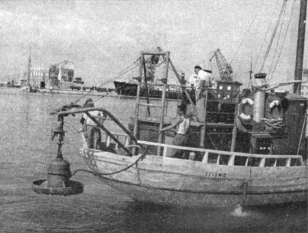
The motorsailer "Istriano", renamed "Seismo", was purchased by OGS for the first measurements in the northern Adriatic. A winch was installed at the stern to lower the bathysphere with the gravimeter to the bottom.

Bookmark
1953
Ship "Francesco Vercelli"
vercelli

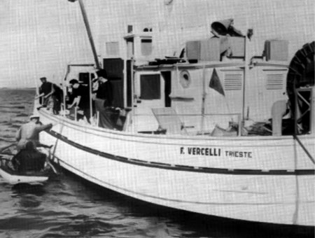
The ship "Francesco Vercelli" owned by OGS (originally a Norwegian deep-sea fishing boat that arrived in Trieste as a fishing-guard vessel during the time of the Allied Military Government) with which gravimetry and refraction and reflection seismic campaigns were carried out in the Mediterranean, oceanography in the Northern Adriatic and, finally, bathymetry surveys along the Italian mainland coasts, Sardinia, Elba Island and the Venice Lagoon.

She was seized by a Yugoslavian patrol boat off Punta Salvore in August 1966 and released after payment of a fine. In 1955, it took part in the first seismic survey in the study for the Messina Straits bridge organised by the Lerici Foundation.

Bookmark
1971
Harmony

Deep-sea fishing vessel, ice class, "Harmony" (flying the Norwegian flag) chartered for the Arctic campaign in Svalbard.

Bookmark
1968 - 1975
Geomar vessel

The vessel is a 30 m long patrol boat of the British Navy. OGS bought it from a furniture manufacturer in financial difficulties and renamed it "GEOMAR". Its first operations for OGS were a reflection seismic study in the Adriatic Sea, then a gravimetric study in the Strait of Sicily, refraction seismic between Calabria and Sicily, a reflection seismic study in the Lagoon of Venice and a geomorphological and oceanographic study for the construction of the gas pipeline north of the Strait of Messina.

The ship's speed, however, lends itself for chemical-oceanographic studies in the northern Adriatic. In particular, a system for the continuous automatic analysis of dissolved nitrates in the sea is being set up, the first in Europe. A Hewlett-Packard 2116B computer is installed on board to acquire data every 30 seconds. Measurement cruises are carried out in the Venice lagoon and in front of the Po estuary.

In 1973, it was used for seismic surveys in the Pozzuoli area for the study of bradyseism (on behalf of the CNR) and then for structural analysis and velocity studies in the Strait of Messina (on behalf of ANAS).

In 1974, a night storm knocked the ship against the pier and sank, then resting on its side. During the salvage the hull was sheared by the harness and the ship was sold in 1975 to a local maritime salvage company.

Bookmark
1988 - 2021
OGS Explora
OGS Explora

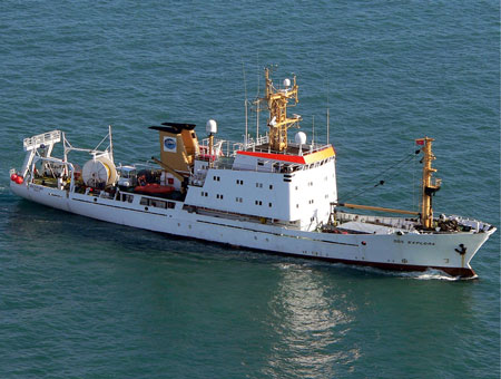
The ship 'OGS Explora' was purchased from Prakla-Seismos. During the first Italian geophysical campaign in Antarctica, it was still called "Explora" and flew the German flag. It reached the limits of the Ross Barrier at 78°S. The vessel was registered as an Italian ship in March 1988 and changed its name to OGS Explora. It carried out 11 Antarctic and 3 Arctic campaigns.

Leggi di più
Bookmark
maggio 2019
R/V Laura Bassi
N/R Laura Bassi

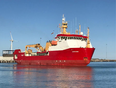
The research vessel "Laura Bassi" was purchased from the British Antarctic Survey (bearing the name Ernest Shackleton, previously the Norwegian ship named the Polar Queen).

Footer menu

Institute

  • About Us
  • Organisation
  • Section of Oceanography
  • Section of 
Geophysics
  • Center for Seismological Research
  • Centre for Management of Maritime Infrastructures

Activity

  • Missions
  • Research
  • Innovation
  • Science for Society
  • Real time data

Infrastructures

  • Maritime infrastructures
  • European Infrastructures
  • Oceanographic Infrastructures
  • Geophysical Infrastructures
  • Seismological and Geodetic Infrastructures

Other

  • People
  • Job opportunity
  • Tenders (IT)
  • Human Resource Strategy (HRS4R)
  • News
  • Intranet
OGS  Home

Contacts

National Institute of Oceanography and Applied Geophysics - OGS
Borgo Grotta Gigante 42/C
34010 - Sgonico ( TS ) - Italy
Tel.+39 040 21401
Fax.+39 040 327307

C.F./P.IVA : 00055590327
Posta Elettronica Certificata: ogs@pec.it

Institute links

  • Albo pretorio
  • Amministrazione trasparente
  • Accesso civico
  • Dichiarazione di accessibilità
  • Statistiche web
Follow us
  • Facebook
  • Instagram
  • Linkedin
  • Twitter
  • YouTube

Small prints

Useful links section

  • Privacy and cookie policy
  • Legal
  • Social media policy