Salta al contenuto principale
Seguici su
  • Facebook
  • Instagram
  • Linkedin
  • Twitter
  • YouTube
it
  • Italian
  • English
Accedi
OGS  Home
Cerca

Cerca

Navigazione Principale

  • L'ente
    • Chi siamo

      • Visione, missione e valori
      • Storia
      • Organi
      • Organizzazione
      • Documenti
      • Onorificenze
    • Sezione di Oceanografia

      • Oceanografia Fisica
      • Oceanografia Chimica e Biologica
      • Dinamica degli Ecosistemi ed Oceanografia Computazionale
      • Infrastrutture di ricerca e Laboratori Oceanografici
    • Sezione di Geofisica

      • Geologia e Geofisica Marina
      • Geofisica Applicata e di Esplorazione
      • Infrastrutture di ricerca e Laboratori Geofisici
    • Centro di Ricerche Sismologiche

      • Sismologia e Geodesia
      • Sismologia applicata all'ingegneria
      • Infrastrutture di ricerca e Laboratori Sismologici
    • Centro Gestione Infrastrutture Navali

      • Gestione mezzi navali
      • Infrastrutture di ricerca e Laboratori Navali
  • Attività
    • Missioni

      • Mari e Oceano
      • Processi geologici
      • Rischio di disastri
      • Aree Polari
      • Scienza aperta
    • Ricerca

      • Progetti
      • Attuazione misure PNRR
      • Bulletin of Geophysics and Oceanography
      • Gruppo Nazionale di Geofisica della Terra Solida (GNGTS)
      • Reti, associazioni e consorzi
      • Pubblicazioni
    • Innovazione

      • Ricerca applicata e servizi
      • Brevetti e invenzioni
      • Cluster tecnologici
      • Partner industriali
    • Scienza per la Società

      • Relazioni esterne
      • Blue Skills
      • High Performance Computing Laboratory (HPC-TRES)
      • The Laboratory on Quantitative Sustainability (TLQS)
      • Comunicazione e divulgazione scientifica
      • Scienza per i cittadini
      • Game based learning
      • Diplomazia scientifica e ambientale
  • Infrastrutture
    • Infrastrutture Navali

      • Nave da ricerca Laura Bassi
      • Mezzi navali minori
    • Infrastrutture europee

      • European contribution to the Argo programme (Euro-Argo ERIC)
      • European Carbon Dioxide Capture and Storage Laboratory Infrastructure (ECCSEL ERIC)
      • Partnership for Advanced Computing in Europe (PRACE)
      • Altre infrastrutture europee
    • Infrastrutture oceanografiche

      • Piattaforma Golfo di Trieste
      • Osservatorio radar a Capo Granitola
      • Stazione Glider
      • Centro Nazionale di Dati Oceanografici (NODC)
      • Centro di taratura e Metrologia Oceanografico (CTMO)
      • Sviluppo tecnologico e supporto acquisizioni in campo (TEC)
      • Collezione di Microorganismi Marini (CoSMi)
      • Vasca navale
      • Laboratori di Chimica e Biologia marina (BioMarine Lab)
      • Osservatorio Mare Artico
    • Infrastrutture geofisiche

      • Geofisica di esplorazione (GeoExp)
      • Telerilevamento aereo (AiRS)
      • Sito test di geofisica di pozzo (PiTOP)
      • Infrastruttura di distribuzione dati geofisici
      • Centro di elaborazione dati sismici e batimetrici
      • Laboratorio di geologia terrestre
      • Laboratorio di geologia marina
      • Laboratorio software sismico (SEISLAB)
      • Laboratorio multi-sensor core logger
    • Infrastrutture sismologiche e geodetiche

      • Sistema di monitoraggio terrestre dell’Italia Nord Orientale (SMINO)
      • Rete sismometrica Italo-Argentina in Antartide (ASAIN)
      • Stazione sismologica Everest (EvK2-CNR)
      • Infrastrutture di distribuzione dati sismici e geodetici
      • Centro di Taratura Sismologico
      • Reti sismiche temporanee e laboratorio mobile
      • Reti di monitoraggio di attività industriali
      • Reti di monitoraggio geodetico di fenomeni franosi
      • Laboratorio di sviluppo sensoristica
  • Persone
    • Personale
    • HR Excellence in Research
    • Supporto ai ricercatori stranieri
    • Mobilità
    • Associati
  • Lavora con noi
    • Gare e appalti
    • Concorsi
    • Altre opportunità
    • Qualificazione professionale
    • Salute e sicurezza dei lavoratori
  • Notizie
    • Notizie
    • Comunicati stampa
    • Cinque per mille
    • Ufficio stampa
    • Risorse per la stampa
  • Contatti
    • Sedi
    • Contatti istituzionali
    • Ufficio relazioni con il pubblico
    • Responsabile della Protezione dei Dati
    • Responsabile per la Transizione al Digitale

PhD: Past and present interactions between the ocean, sediments and ice in Antarctica.

  1. Home/
  2. PhD: Past and present interactions between the ocean, sediments and ice in Antarctica.

Title: Past and present interactions between the ocean, sediments and ice in Antarctica.

Contacts: Michele Rebesco (mrebesco@ogs.it)

PhD Programme: Polar Science of the University of Venice, Italy: https://www.unive.it/web/en/182/home

Curriculum: Earth Sciences.

Where the work will be carried out: Università Ca’ Foscari Venezia and OGS (Italy) + at least six months abroad

More info:
The main goal of the project is to investigate past and present ice-ocean-sediment interactions in the area of the Hillary Canyon (Eastern Ross Sea) to shed light on the sensitivity of the Antarctic Ice Sheet to projected climatic changes for the next centuries. For this scope the research will encompass a full range of time scales, from instantaneous/seasonal using a variety of oceanographic measurements (CTD, lowered ADCP, floats, moorings), to recent (multi-corer, multibeam and sub-bottom) and geologic past (seismics tied to IODP boreholes). This integrated investigation aims at understanding the relationship between seabed morphology, bottom currents, sedimentation and benthic environmental conditions using data from PNRA projects ODYSSEA and IOPPIERS (yet to be acquired on board the first expedition of the icebreaker Laura Bassi in 2024-25) and from IODP expedition 374.

The activity of the Ph.D. candidate will include the analysis of geophysical data (seismic, acoustic and morphobathymetric) and the integration of these with geological data (from cores and IODP wells) and with information from oceanographic data (ADCP, CTD, mooring …).

Borsa DM 630 scienze polari
Info

PhD in Polar Sciences

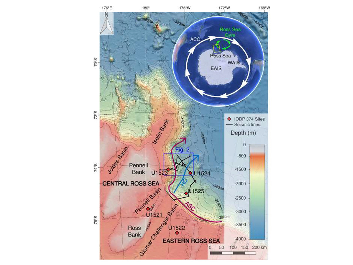
Study area of past ODYSSEA project (and of forthcoming IOPPIERS project). IBCSO bathymetry (Arndt et al., 2013) including the study area with location of newly acquired seismic lines (ANTSSS and ODYSSEA projects) and International Ocean Discovery Program (IODP) Expedition 374 drilling sites (red diamonds). Isobaths every 500 m. The arrows are showing the approximate directions of Hillary Canyon (HC) (blue arrow) and of the core of the Antarctic Slope Current (ASC, purple arrow). In the inset: Antarctic ice sheet with Antarctic Circumpolar Current (ACC), Ross Sea Gyre, West Antarctic Ice Sheet (WAIS), East Antarctic Ice Sheet (EAIS) and the study area (yellow rectangle).

Info

PhD in Polar Sciences

Footer menu

Ente

  • Chi siamo
  • Organizzazione
  • Sezione di Oceanografia
  • Sezione di Geofisica
  • Centro di Ricerche Sismologiche
  • Centro Gestione Infrastrutture Navali

Attività

  • Missioni
  • Ricerca
  • Innovazione
  • Scienza per la Società
  • Dati in tempo reale

Infrastrutture

  • Infrastrutture navali
  • Infrastrutture europee
  • Infrastrutture oceanografiche
  • Infrastrutture geofisiche
  • Infrastrutture sismologiche e geodetiche

Servizi e utilità

  • Personale
  • Concorsi
  • Gare e appalti
  • Human Resource Strategy (HRS4R)
  • Notizie
  • Intranet
OGS  Home

Contatti

Istituto Nazionale di Oceanografia e di Geofisica Sperimentale - OGS
Borgo Grotta Gigante 42/C
34010 - Sgonico ( TS ) - Italia
Tel.+39 040 21401
Fax.+39 040 327307

C.F./P.IVA : 00055590327
Posta Elettronica Certificata: ogs@pec.it

Institute links

  • Albo pretorio
  • Amministrazione trasparente
  • Accesso civico
  • Dichiarazione di accessibilità
  • Segnalazione di accessibilità
  • Statistiche web
Seguici su
  • Facebook
  • Instagram
  • Linkedin
  • Twitter
  • YouTube

Small prints

Useful links section

  • Privacy e cookie policy
  • Note legali
  • Social media policy