
09/03/2026
From the coasts to the marine depths: the structural map of the italian seas is now online
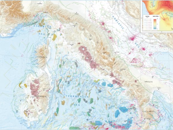
Providing an integrated representation of the main tectonic units and geological structures present in the Italian seas—from abyssal depths to submerged ridges—offering an updated and comprehensive overview of the geological framework of underwater areas: this is the goal of the new Structural Map of the Italian Seas, now available online. The map is a fundamental tool for understanding the geological structures that characterize the seabed of our country.
The map was produced by the Department for the Geological Survey of Italy of the Italian Institute for Environmental Protection and Research (ISPRA), in collaboration with the Institute of Marine Sciences of the National Research Council (CNR-ISMAR), the National Institute of Geophysics and Volcanology (INGV), OGS, and the Universities of Genoa, Palermo, Roma Tre, and Trieste. It is the result of years of joint research carried out by public research institutions and Italian universities.
The project was developed within the framework of the European EMODnet Geology program (European Marine Observation and Data Network), which collects and makes accessible—through a web portal—a wide range of marine geological data acquired over decades in European seas.
OGS served as the reference institution for the Adriatic Sea and also contributed to activities in the Ionian Sea and the Sicily Channel, with the participation of Martina Busetti (OGS coordinator for the periods 2015–2017 and 2019–2025), Valentina Volpi (OGS coordinator for 2018–2019), Michela Dal Cin, and Dario Civile.
The Italian peninsula is almost entirely surrounded by marine basins of different ages, depths, and geological characteristics. Beneath the surface of the Mediterranean Sea lies a complex system of submerged mountains and volcanoes, escarpments, and faults which, over millions of years, have shaped the seabed. This has generated a great diversity of environments, fundamental for the development of biodiversity, as well as the occurrence of major eruptions, earthquakes, and tsunamis.
In this context, mapping submerged territory represents a key step toward improving knowledge of the geological evolution of the Mediterranean and the processes that govern its dynamics. To produce the map, data available in the scientific literature were integrated to provide an overall description of submerged areas and to improve understanding of the geological relationships between the different areas into which the Earth’s crust is divided (domains), in relation to the types of plates that compose it and their interactions.
The map identifies foreland areas (continental regions not yet affected by tectonic movements), subduction zones (where one plate sinks beneath another), volcanic systems, back-arc basins (which open behind volcanic alignments induced by subduction), and Mesozoic oceanic basins. The harmonization and systematization of available information now provide a scientific reference tool that is useful not only for research but also for marine environmental planning and management.
The collected data are strategically important for environmental protection, for the planning and sustainability of offshore infrastructure—such as cables, pipelines, and energy installations—and for safety with respect to risks associated with volcanic and seismic activity, including earthquakes, tsunamis, and submarine landslides. The map may also contribute to the exploration of georesources in the basins surrounding the Italian peninsula, which are closely linked to the geological history of each basin and to inputs from adjacent land areas and deeper regions of the Earth’s crust.
The new Structural Map of the Italian Seas is therefore intended as a reference document for the scientific community and as a solid foundation for the development of further studies and future research. The project is part of the broader European Marine Strategy, promoting the sharing of open and interoperable data to support scientific research and the blue economy, including the search for alternative energy sources—for example, identifying suitable sites for offshore wind farms and geothermal plants—as well as the exploration of potable water resources and other applications.
Link
https://www.isprambiente.gov.it/en/projects/soil-and-territory/emodnet-geology?set_language=en